Caption: Map of UIUC (2001) (South Campus)
This is a reduced-resolution page image for fast online browsing.
EXTRACTED TEXT FROM PAGE:
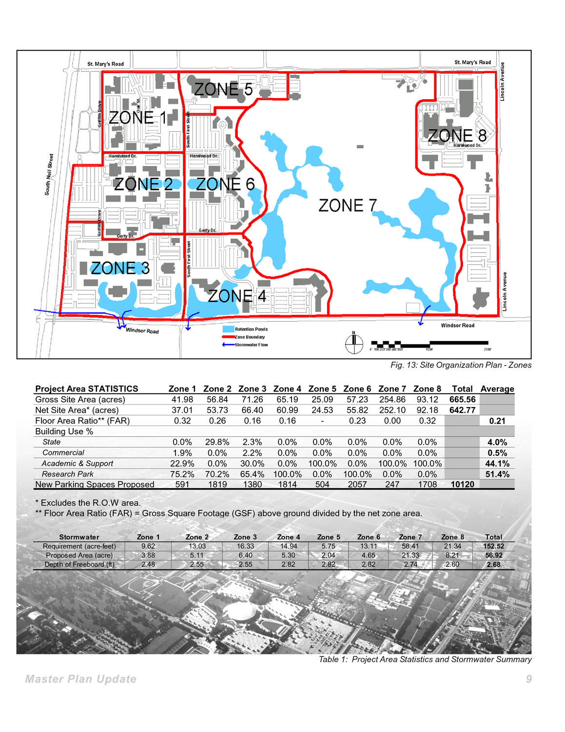
Fig. 13: Site Organization Plan - Zones Project Area STATISTICS Gross Site Area (acres) Net Site Area* (acres) Floor Area Ratio** (FAR) Building Use % State Commercial Academic & Support Research Park Zone 1 Zone 2 Zone 3 Zone 4 Zone 5 Zone 6 Zone 7 Zone 8 Total Average 41.98 56.84 71.26 65.19 25.09 57.23 254.86 93.12 665.56 37.01 53.73 66.40 60.99 24.53 55.82 252.10 92.18 642.77 0.32 0.26 0.16 0.16 0.23 0.00 0.32 0.21 0.0% 1.9% 22.9% 75.2% 591 29.8% 0.0% 0.0% 70.2% 1819 2.3% 0.0% 0.0% 0.0% 0.0% 0.0% 2.2% 0.0% 0.0% 0.0% 0.0% 0.0% 30.0% 0.0% 100.0% 0.0% 100.0% 100.0% 65.4% 100.0% 0.0% 100.0% 0.0% 0.0% 1380 1814 504 2057 247 1708 10120 4.0% 0.5% 44.1% 51.4% New Parking Spaces Proposed * Excludes the R.O.W area. ** Floor Area Ratio (FAR) = Gross Square Footage (GSF) above ground divided by the net zone area. Stormwater Requirement (acre-feet) Proposed Area (acre) Depth of Freeboard (ft) Zone 1 9.62 3.88 2.48 Zone 2 13.03 5.11 2.55 Zone 3 16.33 6.40 2.55 Zone 4 14.94 5.30 2.82 Zone 5 5.75 2.04 2.82 Zone 6 13.11 4.65 2.82 Zone 7 58.41 21.33 2.74 Zone 8 21.34 8.21 2.60 Total 152.52 56.92 2.68 Table 1: Project Area Statistics and Stormwater Summary Master Plan Update 9
|